 Issue 129
 Issue 128
 Issue 127
 Issue 126
 Issue 125
 Issue 124
 Issue 123
 Issue 122
 Issue 121
 Issue 120
 Issue 119
 Issue 118
 Issue 117
 Issue 116
 Issue 115
 Issue 114
 Issue 113
 Issue 112
 Issue 111
 Issue 110
 Issue 109
 Issue 108
 Issue 107
 Issue 106
Perfect for nature-loving 7-12 year olds, each issue of Nat Geo Kids is carefully curated to ignite curiosity and spark conversations about science and nature, empowering children to love and care for our beautiful planet.
NATIONAL GEOGRAPHIC KiDS
WACKY WORLD! • The planet’s strangest pictures…
SLOTHS • Celebrate International Sloth Day on 20 October with these fun facts…
COOL NEWS • Inspiring stories from around the globe…
WORLD CONKER CHAMPIONSHIPS OCT 12
MAKE IT A DATE • Key events for your diary!
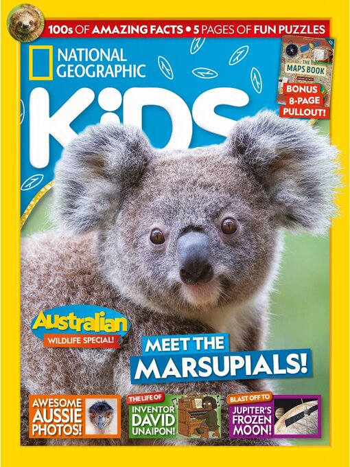
10 COOL THINGS ABOUT KOALAS
MEET MORE MARSUPIALS! • Check out seven spectacular species…
WILD AUSTRALIA • Check out the extraordinary wildlife in these snaps from the Australian Geographic Nature Photographer of the Year competition!
YOUNG CHAMPS • These amazing images were all taken by teens! They were shortlisted in the Junior category, for entrants under the age of 18. Let’s hear about their pics…
THE LIFE OF DAVID UNAIPON • Meet the Aboriginal Australian man who used his brilliant mind to write books, create inventions and push for a fairer society!
INDIGENOUS AUSTRALIA • Find out more about Australia’s First Peoples, the Traditional Owners of this land…
I AM KAM! • Discover the life and artworks of Indigenous Australian painter Emily Kam Kngwarray (say “in-gwah-ray”)
JUNIOR EXPLORERS' CLUB
DESTINATION: EUROPA • Could Jupiter’s icy moon host alien life?
FUN STUFF • GAMES, LAUGHS AND LOTS TO DO!
FUN STUFF ANSWERS
National Geographic Kids (AU/NZ)
EARLY MAPPING METHODS • The peoples of the ancient civilisations of Africa, Asia and Europe built their cities and mapped their lands with simple tools. They also used geometry to take measurements and create plans. Many of the monuments they helped to create – such as the Great Pyramid in Egypt, the aqueduct of Athens in Greece and the Great Wall of China – survive today, but the original tools they used and the maps they made are described only in ancient texts.
MODERN TOOLS • Modern digital mapping tools include hardware, such as satellites, drones, cameras and vehicles, and also the software required to turn the information gathered by the hardware into digital maps. Together, these tools combine to gather information from all over the world, process it and display it on screens. Today, more than eight million people around the world work in digital mapping, in businesses ranging from space agencies to forestry commissions.
DISTORTED VISIONS • The world is a sphere, which makes it difficult to show on a flat map. If you peeled an orange in a single piece and then flattened the peel down, there would be gaps. The same would happen if you took the top layer off a globe and flattened it down. To join up the gaps and create a flat version of a spherical globe, cartographers (map makers) have come up with various ingenious solutions. These are known as projections, and all involve distorting the Earth in some way. With every projection, some areas are made to look bigger and others are made to look smaller than they really are.
SATELLITE MAPPING THE WORLD • In 2010, two German radar satellites began a three-year mission to create a three-dimensional (3D) map of the world. Known as a digital elevation model, it shows the elevation (height) of features across the whole Earth – including mountains, river valleys, canyons, deserts and plains – and is the most accurate 3D world map ever made. Scientists can use it for various purposes – to study environmental change, to watch for natural and human-made dangers, and to plan how to use Earth’s resources in a sustainable way.